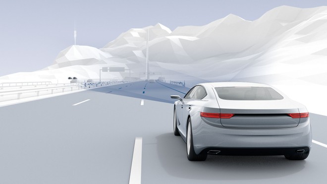
Future self-driving cars must also be equipped with particularly accurate maps in so that they will be able to recognize with extreme precision where they are and what kind of road they are on. For this, Bosch and Volkswagen are working together to collect real-time road data that will improve map accuracy. All this will be; possible thanks to the Golf 8 in circulation in Europe. As they move, these vehicles are capable of providing information for Bosch's road mapping service.
The cloud-based location application uses real-world traffic data detected by sensors to create and update multilevel maps in high resolution.
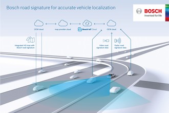
HOW DOES IT WORK?
Detection works like this. While the Golf 8s are on the road, the cars use sensors on board to generate information on landmarks such as road signs, guard rails, curbs and road markings. All this data is then sent to the Bosch Cloud via the Volkswagen Cloud in an absolutely anonymous form . In addition, only the information necessary for the map layers is transmitted. Thanks to all these data received, Bosch creates the road mapping service that can; be seen as a kind of “ digital twin '' real environment.
More there are many vehicles that provide information now and in the future, plus & ugrave; broad and reliable will be; the database for autonomous and assisted driving.
Today, only the Golf 8 is used to collect this information, but other cars will follow in the future. Thanks to Bosch's road mapping service, vehicles will be able to detect their position with greater accuracy. In fact, in real time, the car system compares the sensor information with that of the map.
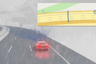
This comparison allows the cars to accurately determine their position in the lane with a deviation of a few tens of centimeters from the highly accurate map. Thanks to the use of radar, the localization works reliably even in adverse weather conditions, such as fog, rain and snow, which make it difficult, if not impossible, for the camera to perceive the surrounding environment.
In addition, road mapping allows self-driving cars or those equipped with Level 2 assistance systems to offer greater reliability; and safety . In fact, it contains information on the morphology and road signs, the layout of the lanes and the speed limits. In the future, road mapping will provide; also information on the driving behavior of cars at specific points on the road. To understand this, motion data such as speed, steering angle and speed are used. of the wheel.
Data are currently being generated for the road mapping service. Starting in 2023, vehicles will be equipped with this and other services. Bosch plans to use the current data to constantly expand the mapping service and keep it updated.
small? Samsung Galaxy S21, buy it at the best price from ePrice at 700 euros .