

At today's AI event in Paris, Google announced or promised many new functions for Google Maps. Immersive View, i.e. the immersive view of cities, should finally start in the first regions. New features are also planned for navigation on foot and for e-cars.
When it comes to “Immersive View”, which Google presented for the first time last spring at the I/O developer fair, you never know exactly what the current status of the technology is, for which regions with which language setting and on which operating systems it is now available is. An app update is not always required for maps, Google often simply activates features on the server side.
This is Immersive View in Google Maps< /h2>
A quick recap: Immersive View is a near-photorealistic city view that allows users to get a bird's-eye view of a city's details, landmarks, traffic, and weather. There is even the option of switching from the street view to the interior view of a restaurant, for example. The new features can be seen in the I/O video from the preset timestamp.
Recommended external content 
Here it is an external content from YouTube, which complements the article and is recommended by the editors. It can be loaded and hidden again with one click.
Load YouTube embeds I consent to YouTube embeds being loaded. In doing so, personal data can be transmitted to YouTube. More on this in the data protection declaration.
Load YouTube embeds Privacy Policy
In May 2022, Google announced that it would soon be offering Immersive View on Google Maps. The launch was initially announced for Los Angeles, London, New York, San Francisco and Tokyo for “later this year”. On a Pixel 7 Pro with Android 13 and an iPhone 14 Pro Max with iOS 16.3 with the latest Google Maps version, the feature cannot be used in the variant demonstrated by Google.
More landmarks from a bird's-eye view
In September 2022, Google made another announcement that they could now offer 250 landmarks with a photorealistic, three-dimensional representation from a bird's eye view for Immersive View. In fact, these views can already be called up as short videos on Google Maps, but they are not an interactive view with weather and more, as was shown at the I/O.
Immersive View is scheduled to be available today
At today's AI event from Google, however, it was said: Immersive View is now available in London, Los Angeles, New York, San Francisco and Tokyo – i.e. in the cities announced last year. The former “later this year” from the original announcement was therefore not correct. On two of the editors' test devices, however, the feature still cannot be called up as interactively as Google presented it today using Amsterdam, the local Rijksmuseum and a neighboring restaurant. Instead, the short video clips for both locations can be started manually via their description.
The feature was rolled out for today's AI event because Google relies on Neural Radiance Fields (NeRF) for its implementation, an advanced AI technique, the company explains, which can convert normal 2D images into a 3D representation. It also takes into account the lighting, textures, and background of the shot to capture the mood of a location as a whole.
In the coming months, Immersive View will expand to include the five cities mentioned above be available in Amsterdam shown in the video, Dublin, Florence and Venice.
Liveview for more cities
Also in the coming months, Google Maps is set to add live view and navigation in Barcelona, Dublin and Madrid, following the recent addition of the feature in London, Los Angeles, New York, Paris, San Francisco and Tokyo. In this mode, the smartphone camera can be used to experience an augmented real-time view of the city, which is enriched with points of interest such as ATMs, restaurants, parks or public transport stops. The user is also shown opening hours and ratings or how busy a place is.
AR navigation for airports and more
An AR view has also been available in Google Maps inside buildings, for example at airports, since 2021. The navigation or the view of the real world is supplemented by AR arrows that lead, for example, to toilets, lounges, taxi ranks or car rental at the airport. After the AR view has so far been available in the USA, Zurich and Tokyo, more than 1,000 new airports, train stations and department stores in Barcelona, Berlin, Frankfurt, London, Madrid, Melbourne, Paris, Prague, São Paulo, Singapore, Sydney and Taipei are added.
New e-car functions for AAOS
There are also new Google Maps functions especially for e-cars with “Google built-in”, i.e. with Android Automotive OS as with Polestar (test). Recently, charging stops can also be added to short routes, with Google giving general charging recommendations for all routes. And there is a new filter for charging stations that only shows the fastest variants from 150 kW. From now on, charging stations will also be displayed in the normal search results of Google Maps, for example if a supermarket offers charging stations.
-
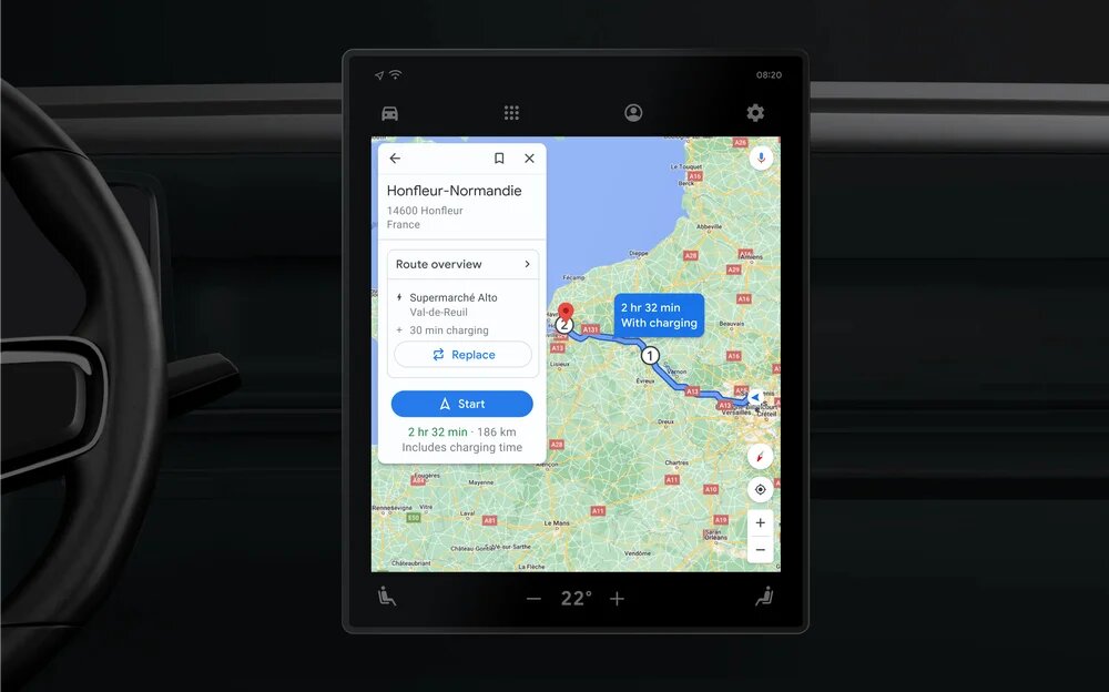 Recommendations for charging stops on all routes (Image: Google)
Image 1 of 3
< figure class="text-asset text-width text-asset--with-border-bottom">
 New filter for chargers from 150 kW (Image: Google)
 Charging stations in normal search results (Image: Google)
New overview of the route description
Apart from the car when navigating on foot, by bike or with public transport, there is an overview of the route description directly in the route overview or on the lock screen new. This view gives users updated arrival times and directions on where to turn next – information previously only visible when the phone was unlocked, the app was open, and navigation mode.
The “clear directions” will be available worldwide in the coming months on Android and iOS will be introduced – from iOS 16.1 also for live activities.