Update September 7, 2022: The environmentally friendly routes in Google Maps, which were already announced in March 2021, are now also available in the Netherlands. Google Netherlands announces this in a blog post. When starting navigation, you can choose the fastest or the most economical route. The most economical route is indicated with a green leaf. The routes, according to Google, were created thanks to a collaboration with scientists and data from the European Environment Agency. Google also uses Google Maps driving trends to determine the most environmentally friendly route. Among other things, the slope, the type of road and speed limits are taken into account.
You can also indicate what the engine type of the vehicle is. You can choose between petrol, diesel, electric or hybrid. Your choice also affects the most environmentally friendly route. You can set this in the route options as soon as you start a route, via the button with the three dots. According to Google, these environmentally friendly options are now being rolled out in the Netherlands. You may not see all functions immediately in Google Maps.
Below is our original article from March 30, 2021
Google Maps is still a popular navigation app on both iOS and Android. If you also want to take the environment into account when navigating, there is good news. In a blog post, Google announces that Google Maps will receive various new functions in the coming months, some of which will also be available in the Netherlands. The most important addition is the eco-friendly routes.
Google Maps: eco-friendly routes and environmental zones
In many navigation apps you can often choose the fastest route or the shortest route. Google Maps now comes with the eco-friendly routes. With this, Google Maps automatically shows the most environmentally friendly route, with the least CO2 emissions. If the eco-friendly route is a lot slower, you can choose whether you still want to drive this route.
If you prefer to always see the fastest route, you can indicate this in the settings. Such routes can be recognized by the green leaf. Google has announced that the feature will be available worldwide for both iOS and Android later this year.

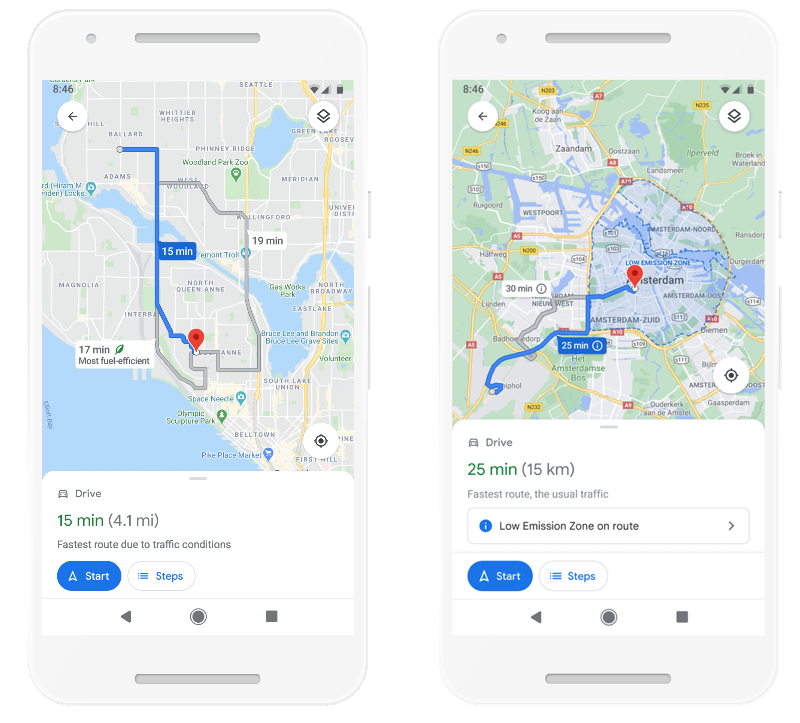
Following on from this are the warnings for environmental zones. Google Maps warns you if a planned route goes through an environmental zone. Many cities worldwide use such environmental zones, where you can be fined if you drive through the center with an environmentally unfriendly car. In the Netherlands, Amsterdam, Rotterdam and Utrecht, among others, have such an environmental zone. Google Maps indicates what the rules are and also shows where the environmental zone is in a box.
This function will be available from June for iOS and Android, including in the Netherlands, Germany, France, Spain and the United Kingdom. You can already see where the environmental zones are in Apple Maps.
Also see 

Avoid environmental zones in Apple Cards
In Apple Maps you can see where the Environmental Zones and Low Emission Zones are in certain cities. This way you immediately know whether you can enter the city with your smelly diesel. Outside the Netherlands, these zones are also called Low Emission Zones or Congestion Zones.
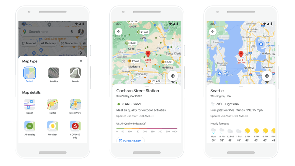
A final addition related to weather and environment is viewing the current weather and air quality on the map. With the weather layer you see the weather forecast per hour. The weather layer can be activated as a map, so that you can see exactly what the weather is like at the locations. This feature will be available worldwide for iOS and Android in a few months. The air quality map layer comes first in Australia, India and the US. Later this will come to more countries.

Google Maps will also make it easier to see how much time it takes to get to your destination using the different modes of transport available. In a single view you can see the difference in travel time between car, public transport or bicycle, without having to switch between tabs. The suggestions for your routes are also adapted to the ways you travel often. If you often go by bike, you will also receive more suggestions. Google Maps also looks at the popular travel methods in the area.
Google Maps gets Indoor Live View
In 2019 Google Maps got the Live View function. This allows you to find your route on foot using augmented reality, because arrows appear in the real environment via the camera of your iPhone. By pointing your iPhone the right way, Google Maps shows you exactly where you need to be. This feature will also be available for indoor navigation, such as airports, stations and shopping centers. You know where the nearest lift, toilets or gates are.

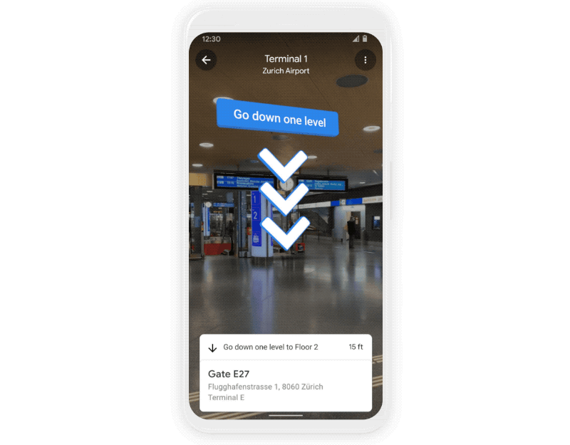
The feature will initially be available in multiple US malls. Airports, shopping centers and stations in Tokyo and Zurich will follow later. Other places will be added later.