Heavy rain follows heat wave. Floods meet parched soils. Satellites cannot prevent such natural disasters, but the data can help us take timely action.
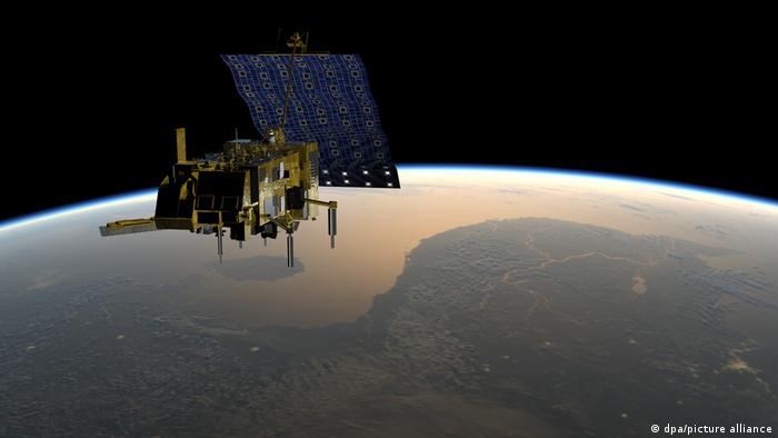
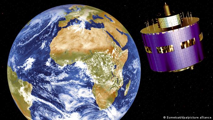
Artist's rendering of the European weather satellite “Metop-C”. The weather satellite was launched in November 2018.
March was the hottest in India since records began 122 years ago, and record temperatures were also measured in Pakistan. Drought aggravated the situation – in both countries around 60 percent less rain fell than usual. But: The heavy rain came with full force, resulting in flooding.
Change of location. There was also recent heavy rain in the South African province of KwaZulu-Natal. The storm caused “unspeakable devastation and massive damage,” the provincial government said. More than 2,000 houses and 4,000 huts were damaged, according to the provincial head of government, Sihle Zikalala. Several bridges collapsed and cars were swept away by the floods.
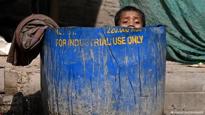
India and Pakistan suffered from an extreme heat wave – then floods followed in many places.
And Europe? This is where Spain and France were experiencing historic heat waves. “This is not normal,” agrees Simonetta Cheli, Director of Earth Observation Programs and Head of ESA's Center for Earth Observation at the Living Planet Symposium (LPS).
Summit of professionals
The LPS is the largest conference on the subject of “earth observation”, the European Space Agency (ESA) organizes it every three years in a different country, most recently in Milan, Italy. In 2022, the symposium was held in Germany for the first time in cooperation with the German Aerospace Center (DLR), at the World Conference Center (WCCB) in Bonn.
This time over 4000 participants from science, technology, politics and business are taking part. There are hundreds of sessions and panels in which results from satellite data are exchanged and their benefits discussed. In addition to measuring the earth, navigation, environmental protection and nature conservation, the precision of agriculture or food security, the focus is also on the potential of satellites with regard to weather and, above all, extreme weather forecasts.
“Satellites are generally very useful for weather forecasting,” says Cheli. In 1977 the first weather satellite was put into orbit, “Meteosat 1”. “Since then, the weather forecast has steadily improved,” says Cheli. However, the prediction of extreme weather events is another topic. Future satellites should provide even more information and make forecasting easier.
Frequency of extreme weather is increasing
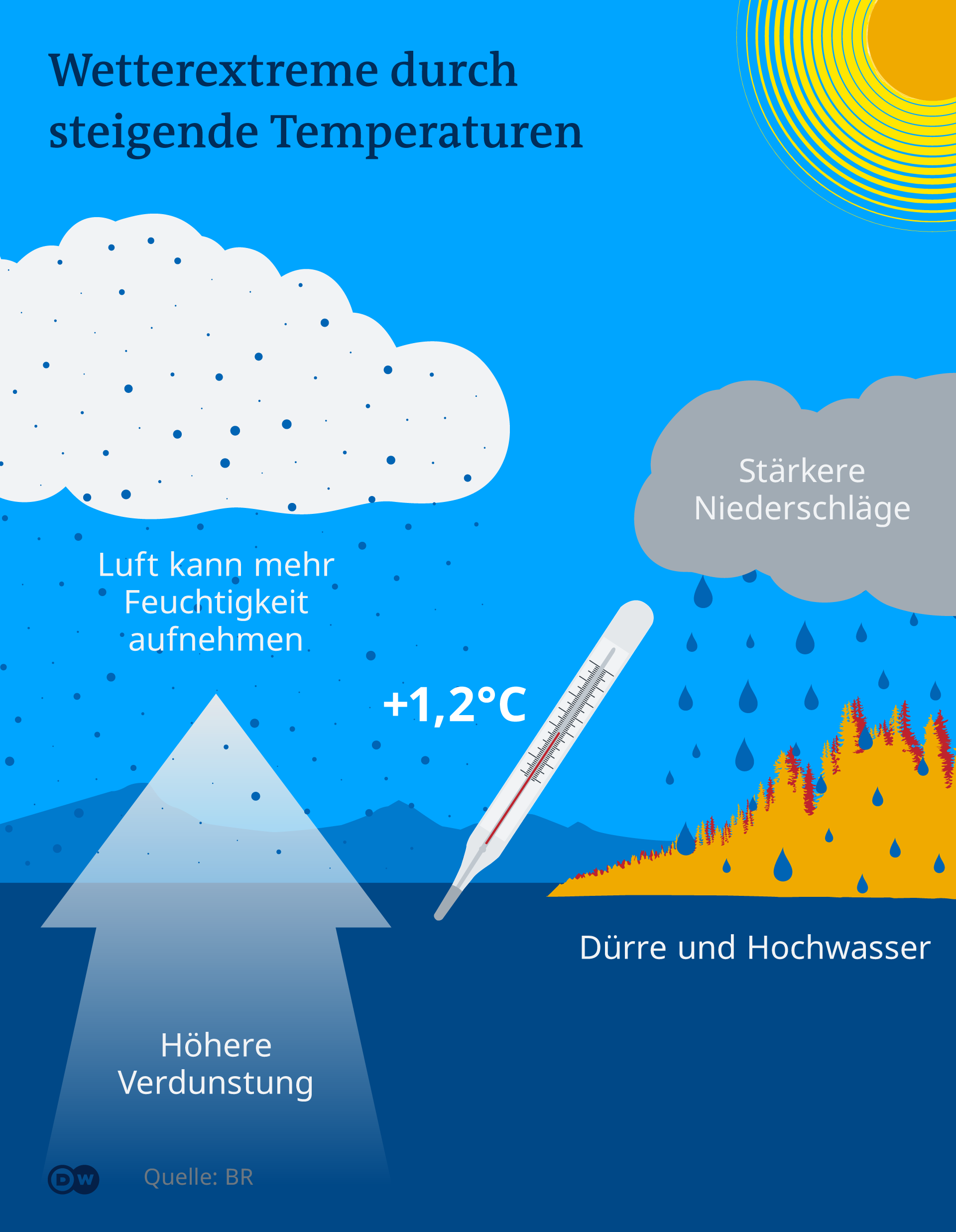
A look back at the last few years makes it clear that extreme weather phenomena such as storms, heavy rainfall, floods, heat waves and droughts are occurring more and more frequently. This development is also confirmed by the latest reports by the Intergovernmental Panel on Climate Change, IPCC for short: Weather extremes will continue to increase.
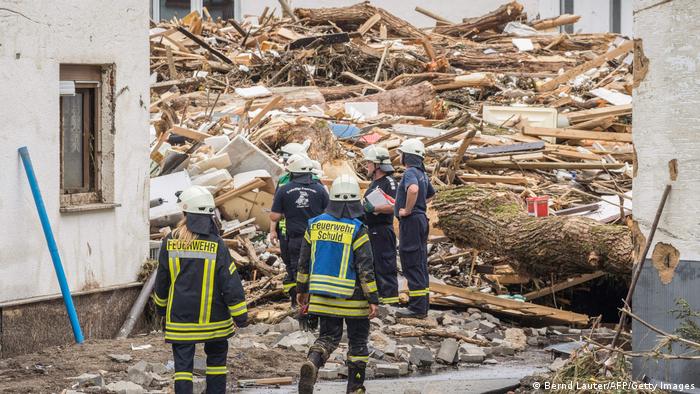
For example, the floods in western and central Europe in the summer of 2021. Extreme rainfall occurred between July 12 and 15, 2021. In the region around the rivers Ahr and Erft in Germany, an average of more than 90 liters of rain per square meter fell every day – an extreme weather, because this was more precipitation than at any time since weather records began.
“As far as I know, the heavy rains were predictable and they were forecast,” Philip Evans told DW. Evans is also a participant in the LPS and he is Director General of EUMETSAT, short for: European Organization for the Exploitation of Meteorological Satellites, a European agency for meteorological satellites (Meteosat and MetOp weather satellites) measuring weather and climate monitor from space.
In fact, a few days before the flood, the European Flood Warning System had predicted a high probability of flooding. On July 12, 2021, the German Weather Service (DWD) informed numerous contacts in Rhineland-Palatinate, including district administrations and fire brigades. The next day, the DWD reinforced its warning: “The next few days will be tough.”
Predictions alone are not enough
“But there are challenges,” Evans continues. “Weather forecasting isn't just about making forecasts. It's about making a forecast, getting it to those who really need it, which is the emergency responders, and they in turn have to decide what to do.” ;
That is exactly what was discussed for a long time after the flood disaster in July 2021: What went wrong with risk management? The tenor when looking back: Extent, responsibilities and instructions for action were not clear enough. According to an expert panel convened by the Science Media Center afterwards, “a concerted action in risk communication” is needed.
- < img src="https://static.dw.com/image/58290650_303.jpg" /> Flood disaster: The urgently needed help
One of the worst flood disasters in German history
More than 100 people have died after the heavy rains in western Europe and the resulting flooding. The federal states of North Rhine-Westphalia and Rhineland-Palatinate were particularly hard hit. It's the worst natural disaster in a long time. Rescue operations are still ongoing in many places – many people are still missing or trapped in flooded houses.
-
 Flood disaster: The urgently needed help
Houses became death traps
Some regions in North Rhine-Westphalia are still flooded. In other places, the damage is visible. The water has even destroyed gas pipelines. Although rescuers warned residents to return to homes at risk of collapse, some searched for family or friends on their own. So some houses turned into death traps when they suddenly collapsed.
 Flood Disaster: The Urgently Needed Help
Clear the Way
The death toll is increasing almost every hour. Thousands of volunteers, firefighters and even around 900 soldiers are involved in rescue or clean-up work. People fear they will find more victims once the waters have completely receded. Only then will the terrible record of the floods become fully apparent.
 Flood disaster: The much-needed help
Saving lives from the air
The house could have collapsed at any second – and many were still trapped inside. In small towns like Schuld and Heimerzheim, the floods have destroyed roads and railway tracks. The residents were isolated from the outside world. In some extreme situations, the police, fire brigade and rescue service as well as Bundeswehr soldiers had to rescue people from their roofs by helicopter.
-
 Flood Disaster: The Much-Needed Help
Onlookers, no thanks!
Round-the-clock operations, recovering bodies, rescuing people: While rescue workers are exhausted, the police warn urgently against “flood tourism”. Onlookers please stay away. “One thing is that they make affected residents feel like they're in a zoo in their front yard,” said Lars Brummer from the Koblenz police headquarters. “The other thing is that they can obstruct escape routes.”
-
 Flood disaster: The urgently needed help
Great willingness to help
Hundreds of families have lost everything and are now homeless. Cities like Cologne and Bonn have organized emergency shelters for evacuees. Aid organizations are also collecting donations and are looking for volunteers to help with the clean-up work.
-
 Flood Disaster: The Much-Needed Aid
Huge financial Damage
First Corona, now the flood: The media report catastrophic damage to roads, public buildings, but also in private companies. The Finance Minister of Rhineland-Palatinate, Doris Ahnen, has promised the flood victims tax breaks. In times when the corona pandemic has already torn the rug from under the feet of many a family, many may need even more help.
Weather forecast: A 'chaotic' system
The daily weather forecast has become something of a matter of course for us, which occupies us emotionally. If the weather is worse than predicted or different than we would like, the mood drops. Only very few have an idea of the effort behind the correct – albeit bad – forecast.
“Weather forecasting is a huge underappreciated scientific achievement,” says Phil Evans. He calls it a “chaotic system” because the smallest change in the system can have a big impact on what happens over the next three, four, or five days. For example, parameters such as humidity, temperature, sea surface temperature and wind are included in the calculations. In addition to satellites, the data comes from weather balloons, airplanes and ships, measuring buoys, weather radar stations, weather stations and automatic ground stations.
However, satellites fill a particular gap here: They provide data from areas that are particularly difficult to access, such as deserts, primeval forests or ocean surfaces. This enables almost complete monitoring. Since 1977, Europe has had its own geostationary weather satellites called Meteosat. You have a view of the earth from an altitude of around 36,000 kilometres.
“But when it comes to weather forecasting, it is a particular challenge to understand what the earth's atmosphere is doing at this moment,” says Evans. That means: around the globe, in all of its atmospheric layers. This snapshot of the atmosphere is used then as a basis for weather forecasts. “That's why Earth observation plays such an important role,” says Evans.
When can we rely on the forecast?
But how reliable is our weather forecast? for the weekend or the coming week? “The current weather models calculate up to 14 days ahead, that's the maximum,” says Evans. “Ten days are more realistic.” The accuracy increases with each additional day.
It is said that the forecast for the coming week is about as reliable today as it was for the next day 30 years ago. The 24-hour forecast achieves a hit accuracy of a good 90 percent, with the 3-day forecast the accuracy is just over 75 percent.
If extreme weather events occur, the forecast depends on the type of the weather event.
-
 Hurricanes – violent events the devastation
Typhoon and Corona Pandemic
On May 14, Typhoon Vongfong devastated the city of San Policarpo in the Philippines' eastern province of Samar with destructive winds and heavy rainfall. At least five people died and more than 91,000 people had to leave their homes. The Philippines are hit by numerous typhoons every year. The Corona crisis is making the situation even worse.
-
 Hurricanes – Forces of Desolation
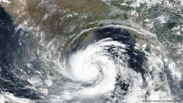
The calm before the storm
Another disaster is already brewing over the sea: Cyclone Amphan is heading for Bangladesh and India. Millions of people are to be brought to safety from the affected areas. In Bangladesh, authorities fear Amphan will be the worst cyclone since Sidr 2007, when around 3,500 people died.
-
 Cyclones – Forces of Devastation
Three names – one phenomenon
Typhoon, hurricane and cyclone – three terms for the same extreme weather: the tropical cyclone. It is called a typhoon off East and Southeast Asia, a hurricane off the coast of North America, and a cyclone off India and Australia. Despite the different names, it is created in the same way.
-
 Hurricanes – Forces of Devastation
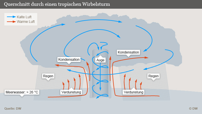
A hurricane arises
Tropical storms form over the sea when water with a temperature of at least 26° Celsius evaporates. The water vapor condenses, the air heats up and pulls cooler air up with it. Wind speeds of up to 350 kilometers per hour occur.
-
 Hurricanes – Forces of Desolation
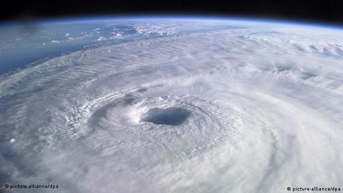
The Eye of the Storm
Due to the rotation of the earth, the air current begins to turn around the eye of the storm, which can be up to 50 kilometers in size. Here it is almost completely cloudless and windless.
-
 Hurricanes – Forces of Devastation
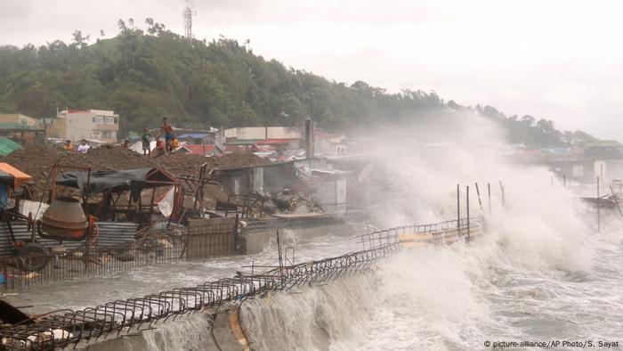
Hurricane hits mainland
When the hurricane hits a coast, it loses power because there is no warm water to follow. The heaviest damage is often caused by the masses of water that the storm brings from the sea. This is where Vongfong meets the coastal town of Catbalogan in the particularly troubled eastern part of the Philippines.
-
Hurricanes – Forces of Devastation
Chaos Foretold
Sandy hit the US east coast in 2012. In terms of area, it was one of the largest hurricanes ever measured over the Atlantic. Tidal waves four meters high, fires, power outages, broken dikes – Sandy raged at more than 145 kilometers per hour over North America. Particularly affected: New Jersey and New York.
-
 Hurricanes – Forces of Devastation
Devastating Consequences
Hurricane Katrina, which devastated New Orleans in 2005, was worse. dams broke. Vast tracts of land sank into the water. The forces of nature were completely overwhelmed by the forces of nature. About 1800 people died. Ten years after the disaster in the same place: Some houses have been rebuilt. But many of those affected never returned.
-
 Cyclones – Forces of Devastation
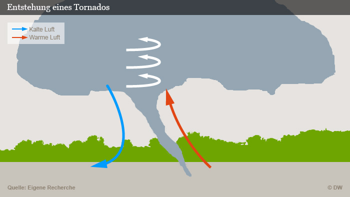
Destructive Vortex< /h2>
Tornadoes, on the other hand, are non-tropical cyclones. They can develop anywhere there are thunderstorms. Due to local temperature differences, warm air strives upwards, cold air falls down, and a column of warm air spirals upwards faster and faster. Tornadoes usually have a maximum diameter of one kilometer.
-
 Hurricanes – Forces of Desolation
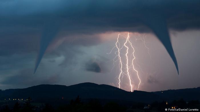
Master of speed among storms
The warm air, which rises quickly, creates a trunk – very characteristic of a tornado. The air speeds there are enormous: the air can reach speeds of up to 500 km/h. This makes the tornado the speed world champion among hurricanes.
-
 Cyclones – Forces of Devastation
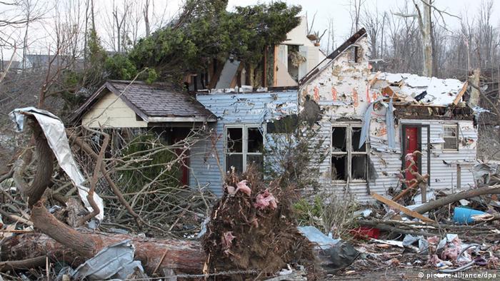
Road of Devastation
A tornado leaves a trail of destruction in its wake several kilometers long. In the American Midwest, tornadoes occur up to a few hundred times a year, where cold, dry air from the north meets warm, humid air from the Gulf of Mexico. In Germany, tornadoes mostly rage on the coasts.
“An extreme weather event that is caused, for example, by a tropical hurricane, which we often see in the US, is a very, very big event,” Evans said. “The course of a hurricane can be predicted with a high degree of probability a few days in advance.”
However, in the case of extreme weather events that are smaller in terms of area, such as tornadoes in the USA or violent thunderstorms in Europe, it is actually impossible to make a forecast. “These can often only be predicted six to twelve hours in advance,” says Evans. So-called nowcasting (“actual forecast”) is often used, with satellite data playing an important role.
From November 2022, the third generation of the Meteosat weather satellites is to be launched: MTG 3rd Generation
A new generation of satellites
However, a new generation of satellites is already in the starting blocks that can collect data on more localized extreme weather events. From November 2022, the three Meteosat satellites of the third generation (MTG 3rd Generation) will be launched.
The new MTGs are intended to track changes in the atmosphere, on land surfaces and oceans even more precisely. For the first time, it should be possible to track the entire life cycle of a storm. This is also the focus of the MTG mission: improving the forecasting of severe storms.
“This will allow us to follow the development and course of these weather events much better,” says Evans. This will have a major effect on the ability to deal with extreme weather events. Philip Evans is visibly excited: “That may sound like an exaggeration, but the MTG 3rd Generation satellite will help save lives.”